THE AWAKENING OF A GIANT
May 18, 1980, at 8:32 AM, a 5.1 earthquake began a mile under the north slope of Mount St. Helens. The series of cataclysmic events it set into motion was so phenomenal that even the geologists who had warned of the eruption for several months were left in awe.
A powerful blast on the north face immediately followed the landslide. In an instant it escalated the velocity of the debris from 220 mph to around 670 mph. Some scientists believe that the landslide momentarily exceeded the speed of sound (767 mph).

DESTRUCTION ON A MASSIVE SCALE
The extraordinary heat generated from the blast instantaneously melted entire glaciers, suddenly releasing 46 billion gallons of water. The water mixed with the debris and acted as a lubricant to the already massive landslide. Enormous rivers of mud, trees, and boulders wiped the landscape clean, leaving only barrenness in their wake.
Trees that had once stood 100 feet tall fell like dominoes over 143 square miles in a region now known as the “Blow Down Zone.” Closer to St. Helens the “Blast Zone,” which was far worse in terms of destruction, spanned a whopping 42 square miles. In the Blast Zone, all of the people, wildlife, and vegetation died instantly from the scorching heat.
Nearby, hundreds of forest service workers, radio operators, geologists, photographers, campers, and others fled the blistering ash and steam rapidly heading towards them. Some people were fortunate and made it out. Many others did not.
The eruption claimed 57 lives that day. Although rescue teams responded immediately, emergency personnel had great difficulty locating people and relaying their whereabouts, because all of the landmarks were simply gone. A moonscape replaced what once had been a familiar landscape of rivers and hillsides covered in trees.

THE ASH
The day began with clear blue skies, but the eruption suddenly transformed it into a post-apocalyptic nightmare. St. Helens spewed out a column of ash 15 miles high, obscuring the sun as it fell over four neighboring states producing an artificial night. Friction from this rapidly moving ash cloud created tremendous static charges that resulted in fierce lightning storms.
Not all of the ash immediately fell back to earth, however. Due to its extremely fine and lightweight nature, much of the ash remained suspended high in the atmosphere where soon it was picked up by the Jet Stream. In a week’s time it showed up in the Southern United States and New England, but it didn’t stop there. Satellite imagery two weeks later showed that ash from the eruption had circled the entire globe.

UNDERSTANDING THE SCALE OF DESTRUCTION
Mount St. Helens did not erupt in a single instant. Rather, the eruption lasted in one form or another for about 24 hours. Approximately 4 hours following the earthquake, a magma chamber four miles beneath St. Helens burst open. The resulting pyroclastic flow down the mountain side of ash, pumice, and gas reached speeds of 100 mph and temperatures of 1500° F. Before all was said and done, a total of 17 pyroclastic flows would transpire. In a 24 hour period, not only had the landscape been rendered completely unrecognizable, but Mount St. Helens had managed to lose 1300’ in elevation.
The scope of the devastation is difficult to imagine. A field of pumice as thick as 120’ in certain areas covered six square miles north of the newly formed crater. The Statue of Liberty, by comparison, is 151’ tall. Imagine six square miles of only slightly shorter versions of the famous statue.
An area 19 miles long and 23 miles wide were completely buried in pyroclastic flows. For those who don’t care to do the math, that’s 437 square miles, otherwise expressed as 211,508 football fields. Deep ash blanketed another whopping 22,000 square miles. The State of West Virginia is 24,230 square miles by comparison.

WHAT TO DO NEXT
As initial damage assessments rolled in, scientists started creating strategies for how to deal with the numerous challenges that lay ahead. Of primary concern were the rivers and lakes. The vast quantities of ash that had been deposited posed a threat to nearby communities and down-stream waterways.
Melting snow and heavy rains each year meant that the probability of mudslides was very high. Additionally, the moving water was certain to carry a great deal of the ash downstream, contaminating other waterways and depositing a tremendous amount of silt into the Columbia River. Human intervention was clearly a necessity.
In the early months of 1981, The Soil Conservation Service took on the enormous task of spreading 10,000 tons of clover and grass seed over the bare ash. The seeds sprouted quickly and helped to stabilize the top of the ash. Although it did not stop erosion entirely, the billions of tiny roots worked together as a mighty force to hold much of the ash in place.
The question of whether or not to replant trees was a matter of some dispute as some people argued that nature should be allowed to rebuild itself while others contended that humans should intervene to speed up the process. In the case of Weyerhaeuser, a paper company that had owned a tree farm there since 1900, they chose to replant the 63,000 acres of trees that they had lost. The company estimated the value of the trees decimated by the eruption to be about $400 million dollars.
Within a few months of the eruption, Weyerhaeuser began planting. In total, they planted 18 million trees by hand to reforest their farms. The trees that grew helped to draw back many species to the area. This increased the biodiversity and biomass, and had a positive impact on the areas that were left to regrow on their own.

THE RELOCATED LAKE
It’s quite hard to imagine a wave 850’ tall (220’ taller than the Gateway Arch in St. Louis), but the landslide created one that big when it collided with Spirit Lake. Although it is located nearly 5 miles from Mount St. Helens, the landslide had so much force when it hit Spirit Lake that the water was forced up into the air in an immense wave long enough for the landslide to completely fill the lake basin. A moment later the water fell back on top of the deposited sediment.
The water couldn’t go anywhere except up because it is bordered by tall mountains in the direction that it was pushed. The mountains also prevented the rushing landslide from exiting the basin. The result was a lake that suddenly had double its original surface area and sat 200’ higher up the mountain slopes.
The US Army Corps of Engineers assessed this alteration and had concerns that annual snow melt might cause Spirit Lake to rise to levels that may create flooding. As a preventive measure, they decided to blast and dredge a tunnel between Spirit Lake and Coldwater Lake to allow the excess water to pass without disturbing the new earthen dam created by the landslide.
A retention structure to hold back sediment was also built by the Army Corps to capture a great deal of the run-off that was inevitable along the Toutle River. Its treeless-hillsides would likely have produced significant erosion that would wind up in the shipping channel downstream in the Columbia River.

UNASSISTED RECOVERY
The decision to leave much of the area untouched (or relatively untouched) proved to be a great idea. Mount St. Helens sits between two major cities in the Pacific Northwest – Seattle and Portland, and as such scientists have had easy access to the area during and after the eruption.
Prior to 1980 Mount St. Helens had been well-studied and photographed by scientists and visitors which meant that there was a wealth of documentation about the area. This unique situation made St. Helens in to a type of “living laboratory” where its ecological recovery and on-going geological metamorphosis could be carefully observed.
These studies revealed a number of unexpected findings, such as the survival of some species in the area that had been presumed annihilated during the eruption. Scientists learned that nocturnal animals had a high survival rate because at the time of the blast (early morning after sunrise), they were already bedded down for the night in their dens. Another unexpected discovery was that many fish lay protected under lakes that were still frozen in mid-May. Perhaps more obvious in hindsight was that due to the time of year, migrating animals were largely out of harm’s way when the eruption occurred. This meant entire populations of fish, birds, and mammals remained virtually untouched.
The process of recovery has been steady, yet slow. Even though many species survived, their entire habitat was gone. They had to adjust to new areas of habitation and had to compete for food with established populations of the same species.
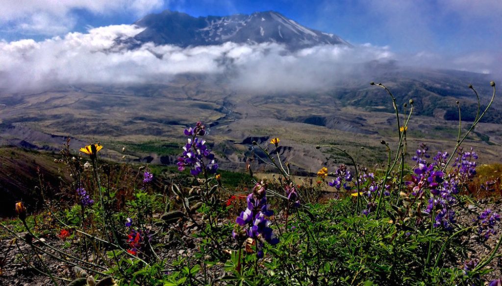
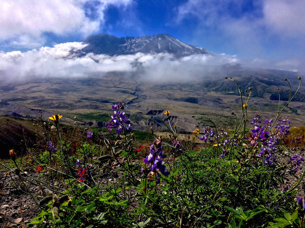
Plants have recovered even slower, as the lack of topsoil has hindered their efforts. After almost four decades the area around the crater is covered in wildflowers and grass, but is still devoid of trees. You can see that they are creeping in like healthy tissue trying to heal a wound. There are shrubs in the vicinity, but they still have a way to go. As you direct your attention outward from the crater, you can see trees become denser the further out that you look.

MOUNT ST. HELENS TODAY
It is tempting to refer to the Mount St. Helens we see today as version 2.0; however, the eruption that occurred in 1980 was one of a number of eruptions that have transpired over the last 3,000 years. It is the sum of these eruptions that have shaped the mountain into what we see today. The area surrounding St. Helens underwent vast restructuring during the eruption, and is still undergoing constant and rapid change (geologically speaking, that is).
For example, The North Fork of the nearby Toutle River previously was fed by Spirit Lake. The eruption buried the river and dammed the lake. Its current origin is in an entirely different place – a new glacier on St. Helens that formed since the eruption. The new North Fork has been carving its way through the thick layers of sediment. As of 2010, the new canyon cut by the the river was 210’ deep.
The blast pattern on St. Helens, which blew off the north face of the mountain, opened a window of sorts into the mountain’s geologic history. Geologists now have access to once buried rock that tells the tale of thousands of years of eruptions. Using this information they have been able to piece together the history of St. Helens, and can tell us how the mountain has evolved.

Another way geologists are able to study St. Helens post-eruption is by examining the terrain around the mountain. Giant chunks of earth were ejected or broken off from the north face during the eruption and landslide. These earthen chunks, referred to as “hummocks,” remained intact and are scattered throughout the area. The hummocks tell geologists things like how much the mountain expanded before the eruption, based on the density of their particles.
Following the eruption, a dome of lava began to grow inside of the vacant crater. Geologists also were able to study this phenomenon closely. They were able to determine that this phenomenon is characteristic of how St. Helens has reformed following eruptions for about 2,200 years.

THINGS TO SEE AT MOUNT ST. HELENS
Visiting Mount St. Helens is an interesting experience. There are so many things to see and do that it is hard to believe that where you are standing was a total wasteland less than four decades ago. At the same time, careful observation combined with a little education about the area brings into focus the numerous tell-tale signs of the cataclysmic event that struck in 1980. It is a paradox of sorts – where there was once beauty, there was total devastation – and as a result of that devastation, there are new beautiful landscapes to behold.
There are two Visitor Centers at Mount St. Helens where you can learn about its history – one near the park entrance and the Johnston Observatory that overlooks the crater. Also of note is the Weyerhaeuser Forest Learning Center which tells the tale of the company’s efforts to rebuild their managed timber areas following the disaster.
Although all three sites are worthy of a visit, the indisputable favorite is the Johnston Observatory. It is named for the late vulcanologist, David Johnston, whose radio message of “Vancouver! Vancouver! This is it!” officially announced the eruption before he was killed by the volcano’s lateral blast.
Most of us are on a schedule when we visit places, and if this is the case for you and you can only make one stop at St. Helens, the Johnston Observatory should be your destination. Be prepared for lots of company. It is insanely busy in high season, but completely worth dealing with the crowds.

JOHNSTON OBSERVATORY
Although the Observatory overlooks the crater, Mount St. Helens still makes her own weather and frequently shrouds herself completely in the clouds. There are never any guarantees when visiting, but if you have a few days in the area it might be a good idea to call the Observatory and find out what the weather has been up to that day.
Mountain weather can change in minutes, so be aware that a report of “it’s currently clear” doesn’t mean you are guaranteed a view by the time you arrive. However, sometimes she stays “socked in” with clouds for several days and the staff can let you know what the weather has been like lately. Even on days where you can’t see your hand in front of your face, she can pop out in full view for fantastic photos before hiding again a few minutes later.

At the Observatory there is an exhibit which has a number of harrowing first-hand accounts of the eruption from people who were on the mountain. The park rangers offer educational talks that are geared for children, but are entertaining for adults as well. There is also a film on the eruption which is like a walk down memory lane if you watched the news coverage as the it was happening.
Understanding what happened where during the eruption is a bit difficult if you are not familiar with the geography. To that end, the Observatory has a fantastic display that recreates the event using LED lights of different colors to show the areas that were affected in each stage of the eruption.
Outside the Observatory there are several trails, both long and short, from which you can see the remaining signs of that fateful day. This particular vantage point makes visible the extensive covering of ash that filled in entire valleys. Many large hummocks, those huge chunks of the mountainside that were relocated elsewhere, are also evident here. A little more difficult to see are the scour lines left by the landslide where entire hillsides were stripped of their topsoil.

WEYERHAEUSER FOREST LEARNING CENTER
If you have the time, be sure to check out the Weyerhaeuser Forest Learning Center. The view from the Center is completely different from what you see at the Observatory since it is positioned right at the edge of the “Blast Zone.” The results of the company’s massive reforestation efforts are plain to see as the area is surrounded by tall forests.
The Learning Center has numerous exhibits showcasing the company’s story at St. Helens. Elk wander the valley of the Toutle River below. The Center likely has someone stationed outside to spot the elk for you and to loan you the binoculars you will need. For people wanting a bit of a different view of the mountain, helicopter tours can be taken from here.

